
Gleirschklamm and Oberbrunnalm
Description: Gleirschklamm and Oberbrunnalm
Location: Scharnitz area
Time: 5-6 hours
Difficulty: Medium - and strenuous in its longest variation
The Gleirschklamm is located in the beautiful Karwendel Alpine Park to the east of Scharnitz. The walking routes in the Karwendel park, such as this one and the Eppzirleralm, are often not attempted during a week's walking holiday because of the availability of other walks which appear more easily accessible from Seefeld, although the public transport connections through to Scharnitz are more than adequate these days.
There are plenty of options to explore the Isar River and the Gleierschklamm, including some easier loops, but the walk described in full is a lengthy day out suitable for fit and experienced walkers. It should also be noted that the Gleirschklamm (or Gleierschklamm, as it is known on some maps) is a narrow gorge which may not be suitable to walk in bad weather (ask for advice at the tourist office in Scharnitz).
Walkers arriving from Seefeld or Reith should take the bus or train to the main stop in Scharnitz. Those travelling from Leutasch may wish to take the bus route via Seefeld or via Mittenwald.
From the village walk towards the Karwendel valleys to the east (a stop can be made at the tourist office and Karwendel information kiosk near the river). Walk over the bridge and take the road into the valley on the southern (far) bank.
Keep walking past the public car park about 200m along the road and follow the righthand road at the next junction and the signs to the Hinterautal, the Gleirschklamm and the Isarsteig. The Isarsteig trail starts between two houses a little further along on the right and has an initial short sharp climb before meandering through the trees with lovely views across the Isar and back to Scharnitz.
Eventually it descends to the river bank again and a bridge which gives access to those who have made the easier but more boring journey along the road on on the northern side of the river. Follow the signs for the Nederweg rather than the Hochwaldweg past the Scharnitzer Alm and along the scenic route above the river Isar.

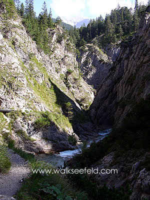
The road eventually crosses a bridge from where the entrance to the Gleirschklamm can be seen. This is signposted with a short history of the use of the gorge for logging in years gone by and a reminder of the necessity for surefootedness and proper footwear.
Those wishing to avoid the gorge, or who are forced to because of bad weather or high water, should take the forestry trail which leads directly up from the information board and eventually joins the forestry road again at the top of the gorge.
Despite the warnings, the gorge is not a particularly difficult walk in good weather. It is however potentially dangerous for children, and there are sections where cables can be used as security for those who are unnerved by the proximity of the water.
Most of the route through the gorge takes place on narrow scree or earth paths, or on wooden boards or rock passages. The scenery is spectacular with some wonderful views up and down the gorge and, as one approaches the top of the gorge, out to the surrounding mountain ranges.
The gorge trail rejoins the forestry track at about the 1200m mark in altitude. From here one can either turn to the left and head to the trail junction for the routes which lead into the Gleirsch valley or over the Isar to the Gleirschhöhe and back to Scharnitz.
Alternatively, turning right and taking the route uphill the route heads to a junction. The right-hand road is the Hochwaldweg which leads through the forest back to Scharnitz. The forestry road to the left rises to the Oberbrunnalm, a hut at 1523m in a majestic position above the Karl and Eppzirl valleys.
After a stop for refreshments here, walkers can take the forestry track down into the Karltal and follow it down to the bus and train stops at Giessenbach. The walk is a pleasant one along a road beside the rushing stream.
Again there is a harder and more spectacular variation which leads up onto the ridge above the Karltal and from where some breathtaking views out over the Karwendel, the Seefeld plateau and the Mittenwald valley are visible. The trail heads up past the Oberbrunnalm on a well-marked path and, once an initial height is gained, is not too strenuous.
Once again, however, this is probably a path best taken in good weather as there are some short steeper and potentially slippery sections - none of which though are in particularly dangerous positions. After reaching the disused ski run above Scharnitz the trail can be taken down to the village or around the front of the Marendköpfl
It is also possible to connect this route to a section of the Tiroler Adlerweg described on the Hochzirl-Giessenbach page.